
Castle of Good Hope
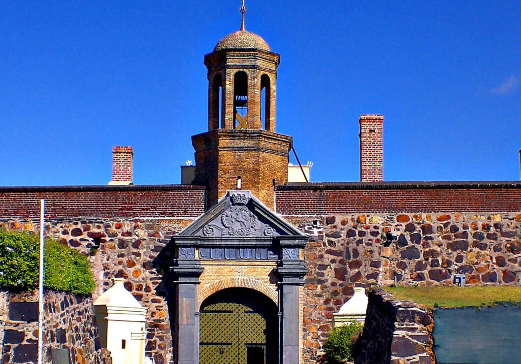
Start at the oldest surviving building in the country. A bastioned pentagon of VOC-era stone at the eastern edge of the centre, and the point from which the rest of this walk runs west.
The Castle of Good Hope is a five-pointed fortress at the edge of Cape Town’s city centre. Built by the Dutch East India Company between 1666 and 1679, it replaced an earlier fort and became a centre of colonial military and administrative power at the Cape.
Today the complex is approached as both a major architectural landmark and a place of layered, often difficult history. Visitors can explore its stone walls, gateways and courtyards alongside museum displays that interpret aspects of life, power and conflict at the colonial Cape.
Exhibitions, tours, ceremonies and access arrangements can change. Check the Castle’s official visitor information before travelling, allow time for security procedures and follow instructions within active or restricted areas.
Cape Town City Hall & Grand Parade
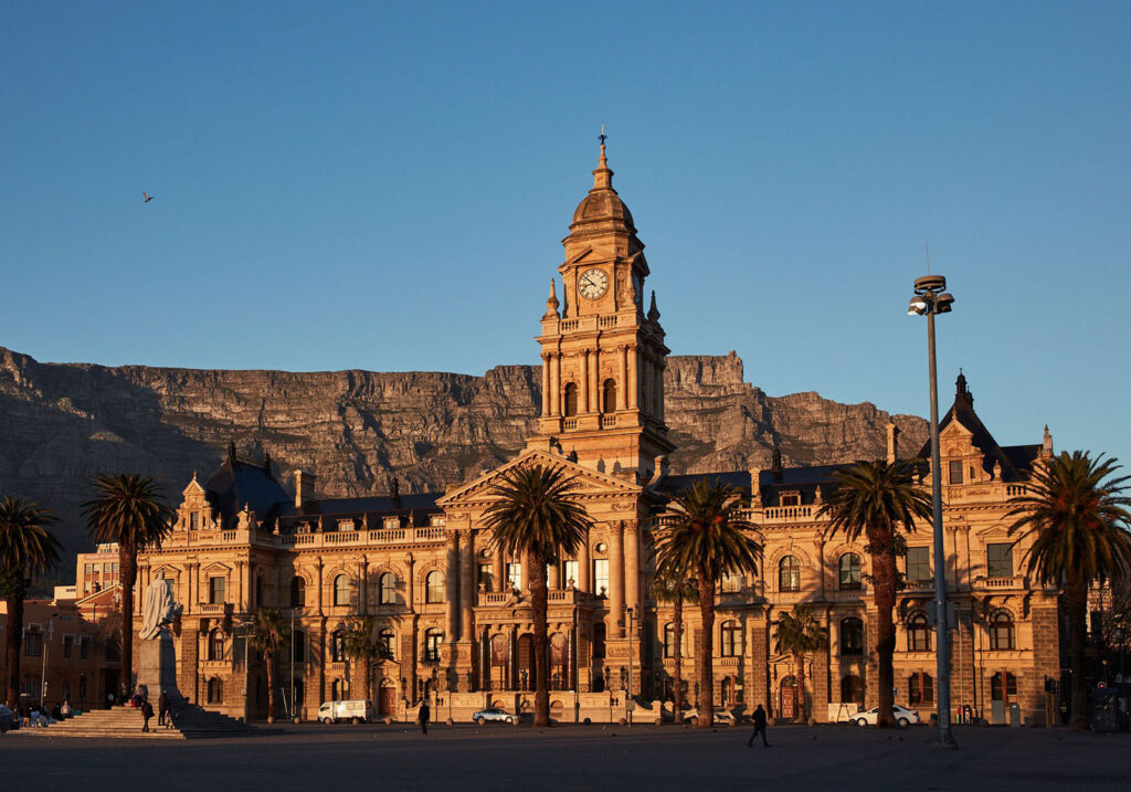
Across the road, the city’s oldest public square and the Edwardian building facing it, whose balcony is where Nelson Mandela made his first speech as a free man in 1990.
Cape Town City Hall stands on the edge of the Grand Parade, a long Edwardian facade in honey-coloured stone with a clock tower at its centre and Table Mountain filling the sky behind it. It is one of the most photographed buildings in the city and one of the easiest to underestimate, because the open square in front of it can look at first like little more than a large paved space with a good view. That square is in fact the oldest public space in Cape Town, and the balcony above the entrance is where Nelson Mandela spoke to the country on the day he walked free.
The building opened in 1905, near the end of a period when Cape Town was growing quickly and wanted a civic headquarters to match its ambitions. It was designed in an ornate Edwardian style, richly worked with columns, arches and carved detail, and built from a warm honey-coloured limestone brought from Bath in England, which is why it glows in low sun in a way no other building in the city centre quite does. The clock tower is a scaled-down echo of the one at Westminster, and it carries a carillon of bells that still sounds across the square.
City Hall served as the seat of Cape Town’s municipal government for most of the twentieth century, until the city administration moved to a modern civic centre in the late 1970s. Rather than falling out of use, the building shifted towards culture. Its auditorium and large pipe organ made it the city’s principal concert hall, and it remains a working venue rather than a preserved monument.
The Grand Parade in front of it is older than the building by two and a half centuries. This is where the Dutch East India Company built its first earth-and-timber fort in 1652, before the stone Castle replaced it a short distance away. Once the fort was gone the ground became a military parade ground, which is where the name comes from, and it has been public open space ever since. Over the centuries it has held drills, proclamations, markets, protests and political rallies, and it is still one of the few places in the central city large enough to gather a crowd.
That capacity is why the square matters. On 11 February 1990, hours after walking out of Victor Verster Prison, Nelson Mandela came here and addressed an enormous crowd from the City Hall balcony. It was his first public speech in twenty-seven years, and the moment South Africa’s transition became visible in the street rather than in negotiating rooms. A bronze statue of him now stands on that balcony looking out over the Parade, which makes the connection legible even to a visitor who arrives knowing nothing about the building.
Standing on the Parade is a useful way to grasp how tightly Cape Town’s history is packed together. The Castle of Good Hope, the oldest surviving colonial building in the country, sits directly across the square. The site of the original 1652 fort is beneath your feet. City Hall represents the confident colonial city of the early twentieth century, and the balcony above its entrance represents the end of the system that city helped build. District Six, cleared under apartheid, began just up the hill. Four very different chapters of the same story sit within a few hundred metres of one another.
As an experience this is straightforward and mostly exterior. You can walk the square, photograph the building from a distance that actually fits it into the frame, look up at the balcony and the clock tower, and then carry on to the Castle or into the rest of the historic centre. The Parade is a working urban space rather than a manicured plaza: parts of it are given over to parking, trading and events, it is busy on some days and close to empty on others, and it can feel exposed when the wind is up. City Hall itself is an active civic and cultural venue, so interior access depends on current arrangements. Check ahead if seeing inside is important to your visit.
Slave Lodge
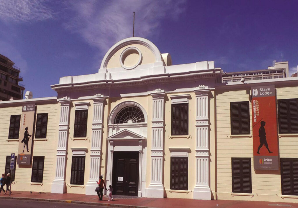
One of South Africa’s oldest surviving buildings, now telling the history of slavery at the Cape through personal stories and the rooms in which it happened.
The Slave Lodge is one of South Africa’s oldest surviving buildings and one of Cape Town’s most significant historical museums. Built in 1679 by the Dutch East India Company, it originally housed enslaved men, women and children brought to the Cape from East Africa, Madagascar, India, Indonesia and other parts of Asia.
Thousands of enslaved people passed through the building over more than a century, contributing labour, knowledge and skills to the growth of the colonial settlement. The museum addresses this difficult history through exhibitions exploring origins, daily life, resistance, freedom and slavery’s lasting impact on South African society.
Today the building forms part of Iziko Museums of South Africa. Restored rooms and modern galleries combine personal stories, historical documents, artworks and multimedia displays with broader themes of colonialism, human dignity, equality, human rights and democracy.
Located near Company’s Garden in central Cape Town, the Slave Lodge combines easily with other City Bowl museums and landmarks. Admission, exhibitions and access arrangements can change, so visitors should check current information on the official Iziko website before travelling.
Church Square
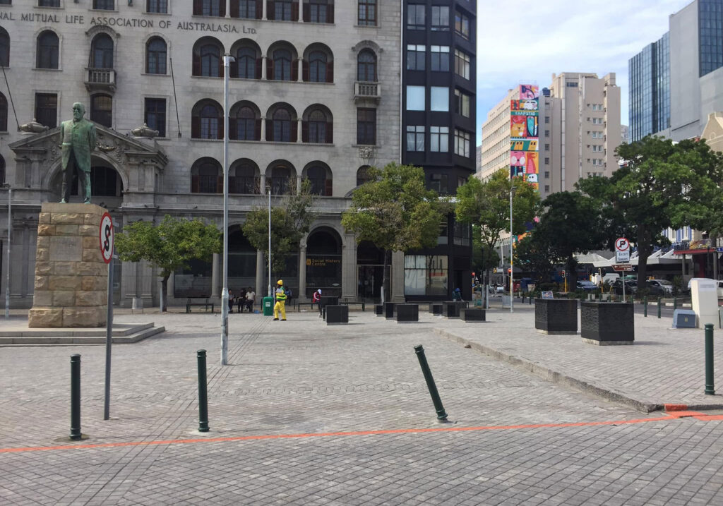
A small paved square behind Groote Kerk where enslaved people were sold at public auction in the decades before abolition. It is easy to walk across without noticing, which is rather the point.
Church Square is a small paved square in the middle of Cape Town’s city centre, set behind Groote Kerk at the corner of Spin and Parliament Streets. There is no gate, no ticket and no building to enter, and the whole space can be crossed in well under a minute. What makes it worth stopping for is that this one block held the Dutch East India Company’s slave lodge, the colony’s first church, its highest court and, for a period in the nineteenth century, the ground where enslaved people were sold at public auction. Church Square is where those things touched each other.
The square was never laid out as a civic set piece. It began as unused ground at the lower end of the Company’s Garden, and its shape was settled by whatever was built around it. The Company’s slave lodge, at the top of what is now Adderley Street, closed off one side in the last decades of the seventeenth century. The Dutch Reformed congregation built on the southern side at the start of the eighteenth century, and that is where the name comes from: Kerkplein, the church square. On the eastern side a silk spinning works operated briefly from the 1720s, and the lane beside it took the name Spin Street, which it still carries. Enslaved children carried silkworm cocoons between that factory and the lodge door.
Groote Kerk gave the square its name and its weekly rhythm. Congregants came in from farms across the peninsula, and the enslaved people who drove them waited outside with the wagons while services ran. Company edicts had forbidden enslaved people from gathering at the church entrances during worship, which pushed that waiting out onto the open ground. The church has its own long and frequently misdated history, and that account belongs to its own page. The effect on the square is the point here: for most of the eighteenth and early nineteenth centuries this was where the enslaved population of a church going town spent its waiting hours.
A large fir tree stood at the Spin Street corner, in front of a drapery shop, and it is the feature most closely associated with the site. The tree was cut down to a stump by the city council on 9 November 1916. In November 1951 the stump and its bronze plaque were removed when Spin Street was widened, and a small octagonal memorial was built on the traffic island the widening created. Its bilingual inscription is brief: “On this spot stood the old slave tree.”
The story attached to that tree has been corrected more than once, and the corrections are worth knowing. The first plaque, put up by the shopkeeper Alfred Hilliard after the tree came down, described enslaved people being displayed on tables and sold beneath it, and the tree was popularly held to date from Van Riebeeck’s time. The botanist Edith Stephens later examined it and put its planting at around 1786, which ruled out the older claim about its age. The auctions themselves are documented. Official sales of enslaved people were held at this corner from 1826, run first by the Sequestrator’s Department and afterwards by the High Sheriff, largely to settle insolvent and sequestrated estates. In 1827 alone 212 people were sold. A May 1829 advertisement listed Hannibal, aged thirty, William, aged thirty five, and Nancy, to be sold by public auction under the trees. The sales fell away in the early 1830s and ended shortly after abolition.
One person keeps the tree in view. A man known as Joemat, who had been enslaved and was later free, kept a fruit and sweet stall beneath it for about thirty five years. His obituary in the Cape Times in 1898 recorded that he had been bought and sold on the same ground where he traded, and his presence there is part of why the spot was marked at all.
Legal emancipation came at midnight on 1 December 1834, followed by four years of compulsory apprenticeship that ended in 1838. After that the square carried on as ordinary city ground. Office buildings replaced the older structures around it, including the National Mutual Life Association building that still dominates the eastern side, and for much of the twentieth century the open ground was used for parked cars. It was declared a national monument on 17 February 1961, which protected the space without changing how it was used. The parking was cleared later and the ground repaved as a pedestrian square.
The memorial to the enslaved was unveiled on the paving in 2008, two hundred years after the 1808 revolt that began on farms in the Swartland and ended at Salt River. It was made by Wilma Cruise and Gavin Younge and consists of eleven granite blocks. Nine stand in a loose grid on the open paving near the slave tree plaque, and two sit on a raised plinth at the south western corner, closest to the Slave Lodge. The blocks share a common footprint but differ in height, which the artists intended to read as common humanity on the one hand and growth on the other. Their top surfaces are polished to a mirror finish, so anyone standing over one sees sky, surrounding buildings and their own reflection. The blocks carry engraved text drawn from the history of slavery at the Cape, including resistance and emancipation.
The memorials on the square do not sit easily together, and that is part of what there is to see. The bronze figure on the tall stone plinth is Jan Hendrik Hofmeyr, known as Onze Jan, a Cape parliamentarian and newspaper editor who died in 1909. It was modelled by Anton van Wouw and paid for by public subscription. In 2015 the plinth was wrapped in white cloth carrying the line “A black woman raised me”, an artwork by Kenan Petersen and Pola Maneli that appeared during the period of protest against colonial statues. On 1 December 2024, Emancipation Day, a gathering organised by the Prestwich Place Project Committee, the District Six Museum and the Institute for the Healing of Memories symbolically renamed the space Freedom Square. That renaming is symbolic rather than official, and the maps still read Church Square.
Physically the square is modest. It is a roughly rectangular paved area, small enough to take in at a glance, with Spin Street and Parliament Street running along its edges rather than through the middle, and bollards keeping vehicles off the paving. There are trees in large planters, some seating, and the Iziko Social History Centre sign on the National Mutual building, which is a collections and archive facility open by appointment on weekdays rather than a walk in museum. Groote Kerk’s tower stands immediately behind and the Slave Lodge is at the far corner. Ten to twenty minutes covers it: enough to read the memorial, cross to the plaque on the Spin Street island and look properly at the buildings around the edge. The value here is understanding rather than spectacle.
There is no admission and nothing to book. This is open ground in a working part of the city, busiest on weekday mornings when Parliament and the surrounding offices are in use, and quiet at weekends. Reaching the slave tree plaque means crossing a live road to a traffic island. Ordinary city centre care applies after dark. Parking means a metered bay or a garage in the surrounding blocks, since the square itself has none.
Groote Kerk
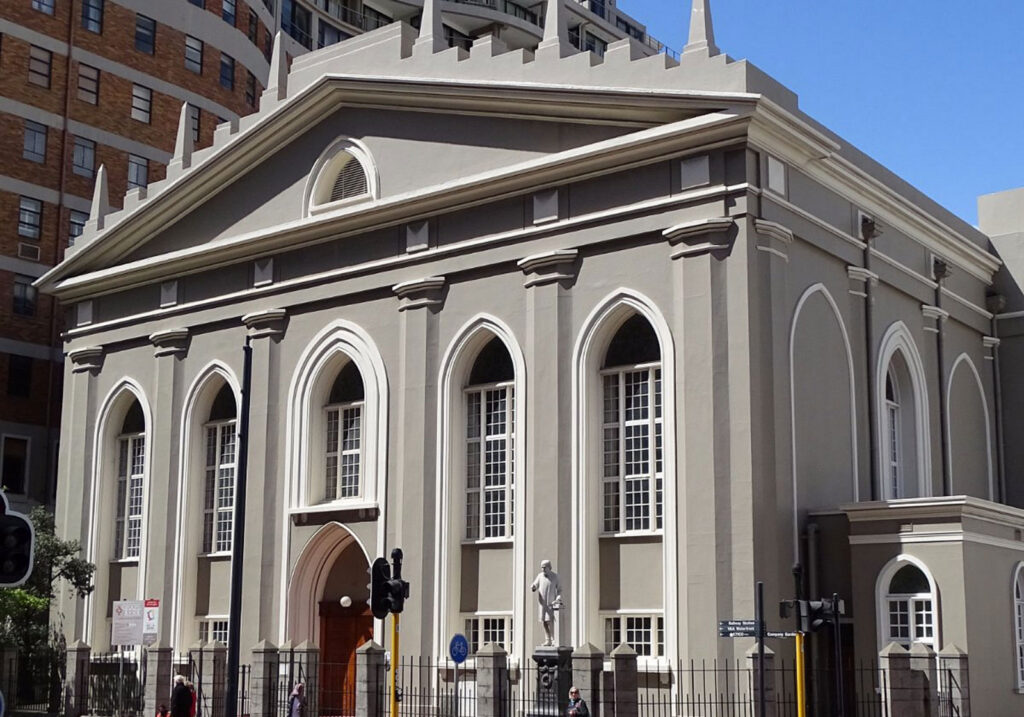
The congregation dates from 1665 and is the oldest in South Africa. The building in front of you is much later, consecrated in the 1840s.
Groote Kerk stands on Adderley Street in the middle of Cape Town’s business district, hemmed in by office blocks and traffic. The front is a broad painted gable with a classical pediment, a row of small pinnacles along the roofline, and tall windows that come to a Gothic point — an unusual combination that makes the building hard to place stylistically and easy to recognise. It is large, plain and pale, and it holds its ground against much taller neighbours. A separate clock tower rises beside it, darker and visibly older than the church it adjoins.
The name means “great church” in Dutch, and the congregation behind it is the oldest in South Africa. Reformed worship arrived with the Dutch East India Company in 1652, when services were held in the fort and led by lay readers. The first communion was administered in May 1652 and the first baptism the following year. The congregation dates itself formally to August 1665, when the first permanent minister, Joan van Arckel, arrived at the Cape. For a period in the 1670s services were held in De Kat at the Castle of Good Hope.
The building came later, and this is where the history is most often got wrong. Foundations for a church on this site were laid in 1678. The cornerstone of a cross-shaped church was laid by Governor Willem Adriaan van der Stel in December 1700, and that church was consecrated in January 1704. It was altered over the following century — the walls were pushed outwards and the cruciform plan was lost — and the structure eventually proved unsound enough to be demolished. The church standing today was consecrated on 31 January 1841, one hundred and thirty-seven years after the first, built by Hermann Schutte on the same ground at roughly ten times the cost. Only the tower of the older church was kept. So the congregation dates from the 1660s, the site has been in church use since the 1670s, and the building itself is from 1841 — three separate dates that are easy to collapse into one.
That history matters because the Dutch Reformed Church was effectively the established church of the Cape under Company rule, and this was its first congregation. Every Dutch Reformed congregation in the country traces back to it. For most of the colonial period, membership here was bound up with civic standing in a small settlement where church, company and government were barely separable.
That entanglement is legible in the streets around the building. Church Square lies just behind the church, at the corner of Parliament and Spin Streets, and within a couple of hundred metres you can stand between the church, the old Slave Lodge at the top of Adderley Street, and Parliament. The Slave Lodge was built by the Dutch East India Company to house the enslaved people it owned, later served as the colony’s supreme court, and is now a museum. A plaque on a traffic island in Spin Street marks the slave market that operated on the square, and a memorial on the square itself remembers the people sold here. The full account belongs to the Slave Lodge, but the geography is the point: the church, the courts, the government and the slave market shared one small block.
If the church is open, the interior repays the few minutes. The pulpit was carved by Anton Anreith from Indian hardwood and inaugurated in November 1789; its bowl rests on the shoulders of two carved lions, each holding a wreath. The organ is very large, with 5 917 pipes, four manuals and a console of 102 stops, and the roof lights above are shaped as proteas. Communion silver more than three hundred years old is still held here, and a number of figures from South African history are buried in the building.
As a visit this is short and undemanding. The church publishes a viewing period from 10:00 to 14:00, though its published wording does not clearly specify which days that applies to. It remains a working congregation rather than a preserved monument, with a Sunday morning service in the traditional style and organ music, so access also changes around services and church events. Check current access before making a special trip. Groups can arrange a guided visit with the church in advance. Outside viewing hours the exterior, the tower and Church Square are still readable from the pavement, and the Slave Lodge, St George’s Cathedral, Company’s Garden and Parliament are all within a few minutes’ walk.
St George’s Cathedral
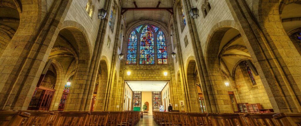
Up Wale Street beside the Company’s Garden. Neo-gothic, cruciform and built around a courtyard labyrinth, and known as the People’s Cathedral for what happened here during the struggle.
St George’s Cathedral stands at 5 Wale Street, at the top end of the Company’s Garden. It is the oldest cathedral in southern Africa and the mother church of the Anglican Diocese of Cape Town, with a reach that extends as far north as the Kunene River. The building is neo-gothic and cruciform, arranged around a courtyard garden that holds a labyrinth, with the cathedral offices in cloisters facing the courtyard.
The cathedral became widely known as the People’s Cathedral during the apartheid years, when it opened its doors to worshippers of all races and served as a gathering point for peaceful protest. Archbishop Desmond Tutu, who was Archbishop of Cape Town from 1986 to 1996, led marches and services from here, and the building remains closely associated with that period.
This is a working church rather than a museum, and it does not publish general visitor hours. Services run through the week. Formal tours lasting about an hour are presented to visiting groups by arrangement, and individuals can telephone the cathedral office in advance to find out when a tour is running that they could join. On the first Thursday of each month there is activity in the cathedral from 17:00 to 20:00, with parishioners on hand to direct visitors.
Greenmarket Square
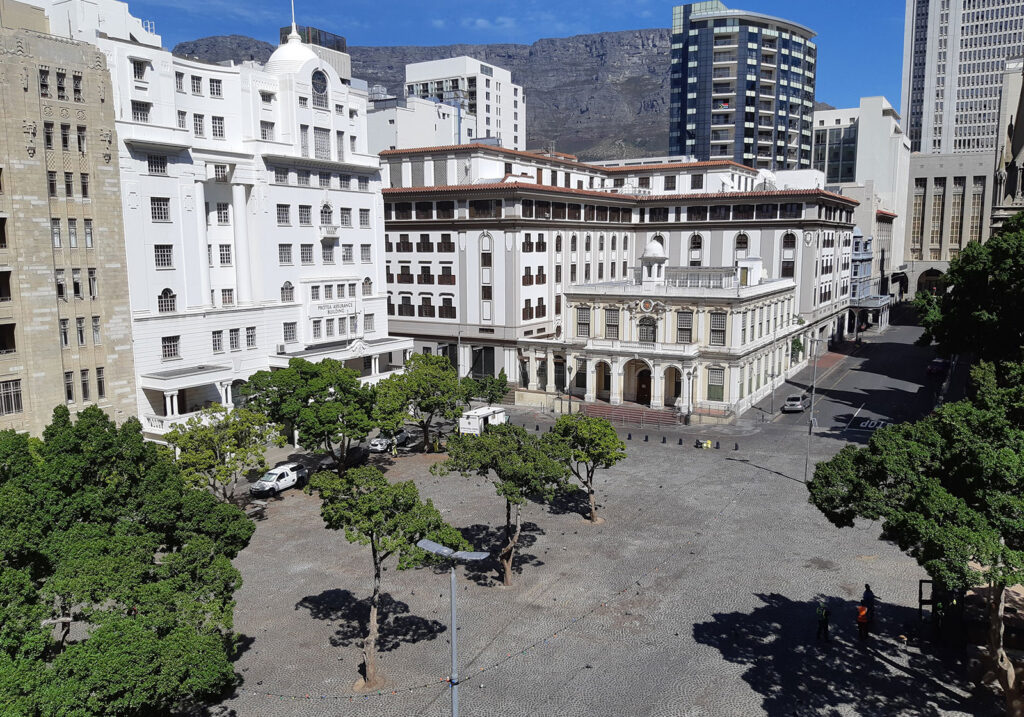
The cobbled square a few blocks down, a marketplace since the eighteenth century and still one, with the Old Town House standing on its edge.
Greenmarket Square sits in the middle of Cape Town’s city centre, a cobbled open space bounded by Longmarket and Shortmarket streets with Burg Street running straight through the middle of it. It is generally described as the city’s second-oldest public square after the Grand Parade, and the ground in front of the Old Town House door is treated as the historical centre of Cape Town. What makes it worth walking to is not any single building but the fact that this one block has been in continuous use, in one form or another, for more than three hundred years.
The square was never designed. It formed. The Dutch East India Company’s garden, a few hundred metres up the hill, was planted to supply passing ships, and produce from it was brought down to this open ground to be sold to the townspeople. Farmers and freed slaves from the surrounding district followed with wagons and carts, and the space settled into its role as the town’s fresh-produce market. That is where the name comes from. In 1696 a burgher watch house was built here, giving Cape Town’s civilian militia a base from which to patrol the streets at night, and from that point the square was both the commercial and the administrative centre of the settlement.
Enslaved people were part of everything that happened on and around the square. They carried the produce, worked the surrounding households and made up much of the labour of the early town, and Greenmarket Square is commonly named among the places in the old central city where enslaved people were bought and sold. That history is set out properly at the Slave Lodge, a few minutes’ walk down Adderley Street.
In 1755 the watch house was replaced by a larger building on the same site: the Cape rococo structure now known as the Old Town House. It housed the burgher council, then served as Cape Town’s town hall for much of the nineteenth century, which meant that for decades the square was simultaneously the town’s marketplace and the seat of its local government. The buildings around it kept pace with the town. Thatched single-storey dwellings gave way to flat-roofed houses of two and three storeys through the eighteenth century, and by about 1840 almost nothing single-storey survived on the square.
Greenmarket Square lost its central role in 1905, when the new Cape Town City Hall opened beside the Grand Parade and both the civic administration and much of the trading moved with it. What followed was commercial rather than civic. Through the 1930s a run of Art Deco office buildings went up around the square, including Market House, Namaqua House and, on the southern corner, Newspaper House, completed in 1936 as the home of the Cape Times and the Cape Argus. The result is the mix a visitor sees now: an eighteenth-century town house, a large Victorian Gothic church and a set of confident 1930s office blocks facing each other across the same cobbles.
Its lowest point came in the 1950s, when the square was turned into a car park. The granite setts that surface it today were laid in the 1960s, using stone lifted from streets being upgraded elsewhere in the city and dressed by hand. The square and the buildings around it were declared a national monument on 17 February 1961. During the 1980s traders began putting up stalls on the parking area, at first only a couple of days a week and then daily, and market trading returned to a square that had lost it eighty years earlier. The same decade gave the square its best-known moment in modern politics: on 2 September 1989, days before South Africa’s racially segregated parliamentary elections, a police water cannon loaded with purple dye was turned on thousands of anti-apartheid demonstrators here. A protester climbed onto the vehicle and redirected the jet, and the office blocks around the square were left stained purple several storeys high. It is remembered as the Purple Rain protest.
The square’s role as a place where the city’s tensions become visible did not end with apartheid. From October 2019 several hundred refugees and asylum seekers occupied Greenmarket Square and the Central Methodist Mission beside it, demanding resettlement outside South Africa after a period of xenophobic violence in the country. The occupation lasted almost six months and ended in early April 2020, when those still on the square were relocated by the authorities.
Trading on the square today is craft and curio rather than produce. Stalls carry wood and soapstone carvings, beadwork, wire art, printed and woven fabric, paintings, jewellery, leather sandals, drums and masks, and a great deal of the stock comes from elsewhere on the continent rather than from Cape Town, which has made this one of the more visibly pan-African spaces in the city centre. Trading is regulated by the City of Cape Town, which allocates bays under an approved trading plan, and a revised plan covering the square and the surrounding central-city trading areas was adopted in 2026. The important thing for a visitor to understand is that the market and the square are not the same thing. The square is permanent. The number of stalls, the mix of goods and the intensity of trading all change, and on a wet winter weekday the square can be close to empty.
The square is smaller than photographs of it suggest, a shallow rectangle of cobbles with a scatter of mature trees, split by Burg Street, and enclosed tightly enough that Table Mountain appears above the rooflines rather than across open ground. Under the trees the stalls stand in rows with narrow lanes between them, and around the edges cafes and restaurants put tables out onto the cobbles. Traders will approach you and bargaining is normal; this is a working market rather than a display. It is also a busy central-city square, so the ordinary city-centre care applies: bags closed and in front of you, valuables out of sight. The cobbles are uneven and hard going for prams and wheelchairs.
The one building on the square you can go into as a visitor is the Old Town House, the white rococo building with the small belfry, which now holds the Michaelis Collection of Dutch and Flemish paintings and keeps its own hours and admission charges. On the Burg Street corner stands the Central Methodist Mission, built as the Metropolitan Methodist Church between 1876 and 1879 and still an active congregation with a long record of social and political involvement in the city. Greenmarket Square works best as one stop on a walk rather than a destination on its own: St George’s Mall runs off one corner, Long Street is a block away, and Adderley Street, the Slave Lodge, St George’s Cathedral, Groote Kerk and the Company’s Garden are all within about five minutes on foot.
Heritage Square
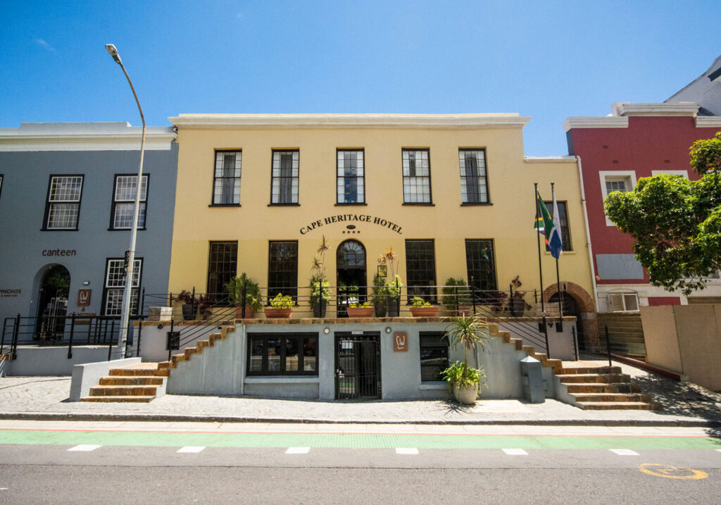
What the Cape Town Heritage Trust calls the largest surviving group of eighteenth-century buildings in Cape Town, one block off the streets most visitors stay on.
Heritage Square is easy to misread. The name suggests an open public square, and it sits directly across Shortmarket Street from one, but it is not a square at all. It is a city block, bounded by Bree, Shortmarket, Hout and Buitengracht Streets, made up of old buildings that were restored in the 1990s and turned back into working premises. There is a signed entrance on Bree Street leading through to an internal courtyard with an old grapevine over it, and around that courtyard are a hotel, restaurants, bars and shops. What a visitor is walking into is a block of the eighteenth-century town that Cape Town very nearly demolished.
The buildings are usually described as eighteenth century, and the Cape Town Heritage Trust calls this the largest surviving group of such buildings in the city. Precise dates are harder than the marketing suggests. A construction date of 1771 circulates widely, but it traces to a claimed land grant rather than to any building record, and a grant dates the plot rather than what stands on it. The block is not uniformly old either: one of its buildings was put up by the Docks Warehouse Company in 1902. What the Trust describes is a group of town houses with their outbuildings and a warehouse, altered repeatedly, giving the block a character it dates to the early nineteenth century.
That layering is the point rather than a flaw. These were working buildings that were changed as their owners and uses changed, and the restoration set out to keep the evidence of those changes rather than strip them back to a single chosen year. The Trust’s account describes handling each building so as to retain as many elements of its successive alterations as possible, producing what it calls an eclectic mix. Nobody reconstructed a fake 1780 streetscape here.
The block survived by a narrow margin. It stood in the path of an extensive ring road scheme for the city, including a proposed Buitengracht Freeway, which would have taken the whole Bree and Shortmarket block for a parking garage along with other old buildings on Hout and Shortmarket Streets. Published accounts disagree about when this was proposed and fought, placing it anywhere from the 1960s to the 1990s. What is consistent is who resisted it: the Simon van der Stel Foundation and the Institute of Architects led the opposition, with support from the city councillor Joan Kantey and from journalists including Victor Holloway.
The Cape Town Heritage Trust was established in 1987 by the City Council with backing from the provincial administration. The council-owned properties on this block were donated to it in 1996, and the restoration was finished in the middle of 1998. It became the Trust’s largest project. The conservation architects were David van den Heever, of GAPP, and Trevor Thorold, with Hennie Fagan as structural engineer, Resnekov and Nielsen as builders and Tony Davenport as project manager.
Before the main contract began the team spent six weeks investigating the buildings, and the Trust records that this turned up things nobody knew were there. An eighteenth-century door was found bricked up on both sides, still carrying its original lock and handles. Archaeological excavation was carried out, and scraping exposed historic decoration on the walls. The value of doing that work first was that the design could be settled with the discoveries already known rather than running into them halfway through.
The principal building, 90 Bree Street, had come closest to being lost. Decades of neglect had reduced it to little more than a shell, and by the Trust’s account it survived only because a temporary roof was put over it during the 1980s. It is now the Cape Heritage Hotel.
In its courtyard is a grapevine that the Cape Town Heritage Trust describes as the oldest surviving grapevine in South Africa, estimated to have been planted in the 1770s. The estimate is worth taking as an estimate: other accounts give 1771 or 1781, sources disagree over whether it is Chenin Blanc or Crouchen Blanc, and no dating evidence has ever been published for any of the figures. Other old vines carry similar claims, including one in the Company’s Garden. What is documented is more recent and more interesting. The vine developed Eutypa dieback, a disease that attacks the wood, and was treated and rehabilitated, its tendrils secured and a new support structure built so that it could spread further across the courtyard. Cuttings were taken and planted in the Company’s Garden in 2020. Small quantities of wine have been made from its fruit, sold at auction to fund its upkeep.
The Trust also records that its joint venture with the businessman Sam Montsi made Heritage Square the first post-apartheid inner-city development in Cape Town involving a Black developer. That account comes from the Trust itself and has not been independently corroborated. Montsi’s career is well documented otherwise: he was the first Black general manager in the South African Breweries group, and went on to build interests in fishing, shipbuilding, property and mining.
The precinct is busy and has stayed that way. Tenants have turned over considerably, as they do anywhere, but the hotel is operating and the restaurants, bars and shops around the courtyard are trading. There is no admission charge, no ticket office and no visiting hours, because Heritage Square is not run as an attraction. Nobody publishes access arrangements for the precinct as a whole, and no guided tours of it are offered. In practice a visitor walks in from Bree Street, looks at the courtyard and the vine, and either sits down at one of the businesses or does not.
The relationship with Riebeeck Square across Shortmarket Street is worth understanding, because the two are constantly confused. Riebeeck Square is the open square on the uphill side, a former farmers’ outspan now largely used for parking, with St Stephen’s Church on its Bree Street edge. Heritage Square is the built block on the seaward side. They are neighbours with a shared history of nearly being cleared for traffic, and the practical link between them today is that Heritage Square directs its visitors to park in Riebeeck Square.
The argument the Trust set out to make here was that conservation and commercial development are not mutually exclusive, and that a historic block could pay for itself rather than being emptied out and preserved as an exhibit. Three decades on, that is what the place demonstrates. Heritage Square survives not because it was sealed off from the working city, but because it was put back into it.
Strand Street Lutheran Church
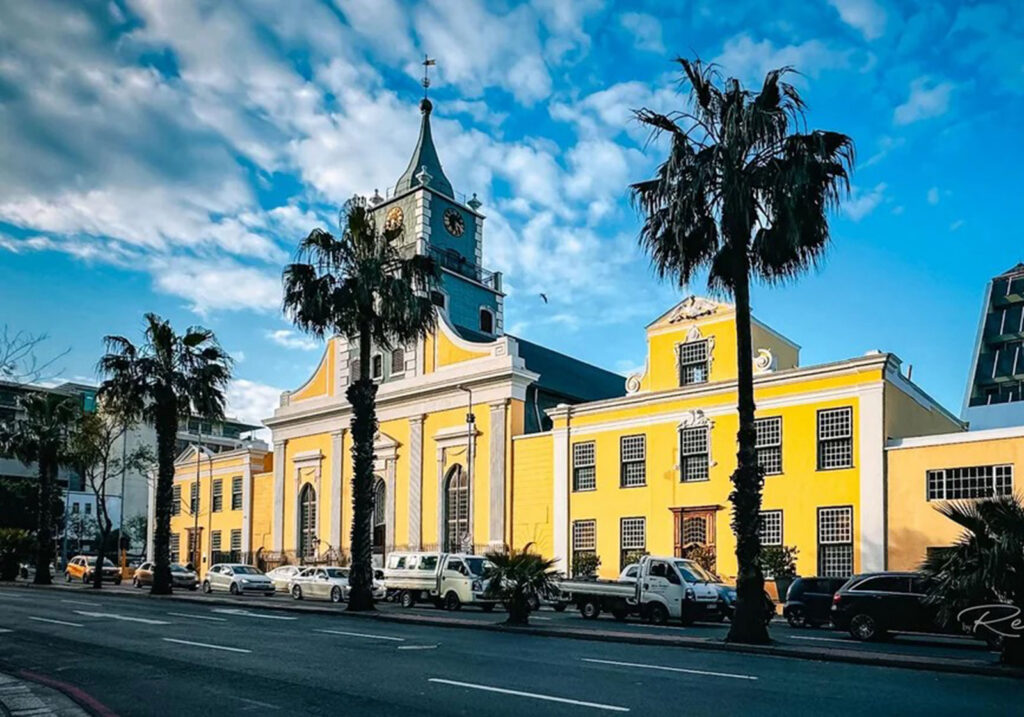
Begun in 1774 as a hall shaped like a warehouse, because the Dutch Reformed Church was then the only publicly recognised denomination at the Cape. Martin Melck House stands beside it.
The Strand Street Lutheran Church is the yellow-washed range about halfway along Strand Street, set behind a line of palms with traffic running past the door. The church itself carries a curved Cape gable and a square tower with clock faces and a slender spire, and the buildings continue on either side in one long eighteenth century row. The tower is the detail worth knowing about first, because when this congregation was finally allowed to exist, one of the conditions imposed on it was that it could not have one.
Under the Dutch East India Company the Reformed Church was the only publicly recognised denomination at the Cape. That did not mean Lutherans were hunted. They were admitted to Reformed communion as early as 1665, and from the 1730s they were quietly permitted to hold services when a Lutheran chaplain came through Table Bay on a Danish or Swedish ship. The penalty was applied to careers rather than to worship: by the 1770s it had become an informal requirement that Company officials be Reformed, and in the 1780s the Heren XVII ruled that no Lutheran could sit on the Councils of Policy or Justice. Many joined the Reformed Church in order to hold office at all.
In the meantime they worshipped in private houses, with prominent Lutherans converting a room into a place of worship, on the model of the hidden churches of Holland. In 1741 the authorities counted 509 confessing Lutherans at the Cape. The following year sixty-four of them, fifty-seven German, signed a formal application for their own congregation and pastor. It was refused, as were further requests in 1743, 1751 and 1753. What eventually worked was not persistence at the Cape but a change of route: towards the end of the 1770s the Lutheran Church in Amsterdam approached the Heren XVII directly, without informing the Cape government.
By then the building already existed. Martin Melck, a Prussian-born wine and stock farmer who had become the wealthiest man in the colony, put up a hall on this site in 1774 in the form of a warehouse or barn, and it passed into Lutheran hands within two years. It was in use for worship from 1776. Quite how much of a disguise it was is a matter of judgement: one historian of Cape Lutheranism describes it as provisionally disguised as a wine storehouse but having the interior of a church, while the congregation’s own history calls it simply a warehouse or barn. The dimensions recorded for it, roughly twenty-nine metres by twenty, with a domed ceiling and rows of thick rectangular columns, are not those of a store. Melck gave it in his lifetime; he died in February 1781, so nothing here came by will.
Recognition came on 18 October 1779, when the congregation numbered around 440 people. It arrived heavily conditioned. The Lutherans wanted Christiaan Frederik Blettermann, Cape-born and trained at Halle and Leipzig; the governor would allow only a Dutch-born pastor. Services had to be in Dutch, though sermons could rest on the Augsburg Confession. There was to be no tower and no altar, and a lectern the congregation already owned had to be taken out after complaints from the Reformed clergy. Andreas Lutgerus Kolver arrived from Rotterdam on 22 November 1780 and held the first service on 10 December. From 1783 Lutheran baptisms were placed under tighter control. Equality waited another twenty-five years, until the church order issued by Commissioner-General de Mist in 1804 put all denominations on the same footing.
The sequence is worth keeping straight, because it is the point of the place: the building was in use from 1776, the congregation was recognised in 1779, and it was constituted and its church consecrated in 1780. Lutherans worshipped here for several years before their congregation received official recognition.
Between 1787 and 1792 the interior was transformed by the sculptor Anton Anreith. The pulpit is the centrepiece, carried on two great male figures with a carved swan above it, the swan being the Lutheran emblem. The same campaign produced the choir stalls, the lectern, the carved doors to the vestry and to the rear, the carving above the entrance, the figure of King David with his harp on the organ loft, the case of the organ, and the memorial plaque to Melck at the entrance. The attribution to Anreith is universal and long-standing, though no contract or payment record for it appears in the published literature.
Anreith also designed a front elevation for the church, and this is where most accounts go wrong. It did not survive. In 1818 the roof needed replacing and the walls were found to have tilted dangerously, and the building had to be rebuilt completely. The work ran to 1820, and it was in the course of it that the tower went up, with three bells, on the spot where Anreith’s pediment had been. The church was re-inaugurated on 20 December 1820. Anreith’s front is known today only from drawings made by Lady Anne Barnard and John Barrow. What a visitor sees from Strand Street is the 1820 building, and no picture of the original warehouse exists at all.
Inside, the Anreith fittings are what survive, along with the fabric of 1820. The altar table standing in front of the pulpit and the cross fixed to the wall beside it are recent by comparison, added during a ministry that ran from 1960 to 1973. A large organ was installed in 1814, which means the instrument sits inside a case that is roughly a quarter of a century older than it is.
The language history is its own small comedy. A congregation that was overwhelmingly German was required to worship in Dutch as a condition of being allowed to worship at all, and then kept Dutch for a hundred and seventy-nine years. The hymns stayed German, sung from a Bremen hymnal adopted in the 1780s and used for at least a hundred and twenty-five years. English evening services began in 1889. Afrikaans replaced Dutch in the morning services only in 1959, was dropped in 1973, brought back in 1980 and dropped again in 1991. Services today are in English.
The congregation has split twice in ways that still shape central Cape Town. In 1847 the second pastor, G. W. Stegmann, left with a body of members over changes he had made to the baptism liturgy, his strict moral positions and his pastoral work among people freed from slavery, which had already produced the congregation that became St Stephen’s on Riebeeck Square. His breakaway built a church in Long Street in 1853 and had ceased to exist by 1858. Then in 1861 Pastor Johann Ludolph Parisius, unable to accept an order of service that had been imposed in 1780 and was by then defended as tradition, founded the German-language St Martini congregation, which bought the Long Street building. Two Lutheran congregations have existed side by side in the city centre ever since.
The church stands in the middle of a group of three. To one side is the Martin Melck House, begun in 1781 as the Lutheran parsonage and notable for its dakkamer, a roof room with four windows that once looked out over the whole of Cape Town and Table Bay. It housed the Gold of Africa Museum from about 2000, but the museum fittings were taken out in 2018 and the house is now occupied by the church rather than open to the public. On the other side is the Sexton’s House, built between 1779 and 1783, which today houses the Consulate-General of the Netherlands. All three are protected as provincial heritage sites, declared separately rather than as one group, and Koopmans-de Wet House stands opposite.
The church is in use, with a Sunday morning service in English at nine. It publishes no visiting hours and there is no congregation website, so anyone who wants to see the pulpit should contact the church in advance rather than arriving unannounced. From the pavement the row reads clearly enough on its own: three eighteenth century buildings still standing together on a street that has otherwise been rebuilt around them.
Auwal Mosque
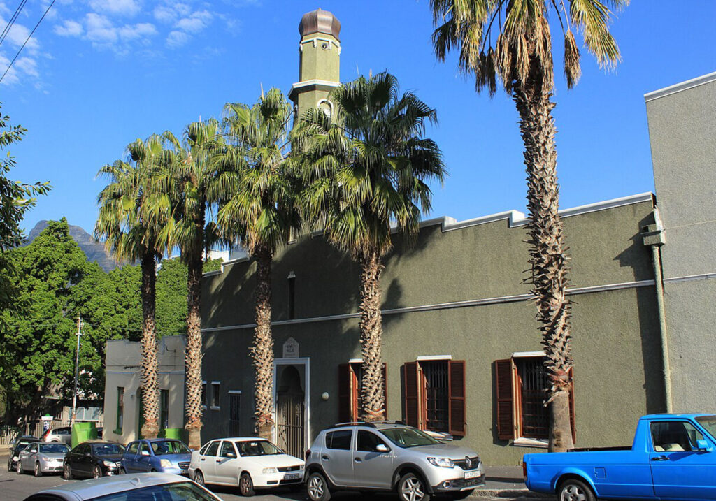
Finish on Dorp Street in the Bo-Kaap at the oldest mosque in South Africa, an active congregation rather than a historic interior kept for visitors, and the site of the first madrasah in the country.
Auwal Mosque stands on Dorp Street, on the lower slope of Bo-Kaap, in a terrace that gives very little away from the pavement. The frontage is long and low, rendered in a dark grey green, with brown shuttered windows and a small arched doorway set back under a name plaque. A slender minaret with a copper dome rises behind the roofline, and the palms along the kerb hide most of it. Visitors photographing the painted houses higher up the hill often walk past without registering what they have passed. This is the oldest mosque in South Africa, and it is still in daily use.
The date attached to Auwal is 1794, and the congregation keeps it: in September 2024 it marked 230 years. What happened in that year is more particular than the familiar phrase “built in 1794” suggests. The property was a warehouse belonging to Coridon van Ceylon, a freed man and one of the first Muslims to own property in Cape Town, who bought two adjoining Dorp Street plots on 26 September 1794. The building was brought into Muslim religious use by the construction of a mihrab, the niche that marks the direction of prayer. That was a change of use, not a building project.
The structure visitors see came later. The City of Cape Town’s heritage record for Bo-Kaap dates the erection of the original purpose-built mosque to between 1809 and 1814, and notes that the title still stands in the name of Saartjie van de Kaap, Coridon’s daughter, to whom the property passed. Extensive rebuilding followed in 1936, and a survey of the building in the 1980s found only two of the original walls intact. Auwal’s continuity is therefore a continuity of congregation and of ground rather than of masonry. The 1794 date belongs to the founding of the mosque and to the beginning of worship on the site it still occupies.
Teaching arrived before the mosque did. Around 1793, in the same Dorp Street warehouse, Tuan Guru opened the first madrasah in South Africa. He was Imam Abdullah ibn Kadi Abdus Salaam, born in 1712 on Tidore in the Ternate islands, in what is now eastern Indonesia, where he held religious and judicial office at the sultan’s court. Dutch East India Company records state that he had conspired with the English against Dutch interests, and he was banished to the Cape, arriving on 6 April 1780 aboard the Zeepard at the age of sixty-eight. His years of confinement are associated with Robben Island, although how long he was held there, and whether without interruption, is not settled. While in custody he completed a substantial work on Islamic jurisprudence in 1781 that became a standard reference for Cape Muslims through the nineteenth century. He was free by 1793 and spent the rest of his life teaching. He died in 1807 and is buried at the Tana Baru cemetery above Bo-Kaap.
The school mattered at least as much as the mosque that grew around it. It was open to enslaved people and to the Free Black community, neither of whom had access to colonial schooling, and it grew quickly: roughly 375 pupils by 1807 and 491 by 1825. For many of them it was the only formal education available, and it was education in literacy as much as in religion.
That has a consequence which reaches well beyond the congregation. Teaching at the madrasah moved over time from Malay into the Dutch spoken at the Cape, but it continued to be written in Arabic script, because Arabic letters were what the pupils learned first. The religious texts produced this way are known as Arabic-Afrikaans, and they are among the earliest surviving written records of the language that became Afrikaans. One of the more consequential things ever to happen in a Cape Town classroom happened in this one.
For most of the Dutch period, public Muslim worship at the Cape was not permitted. Prayer took place privately or out of sight, and congregational prayers were held for a time in a quarry on Chiappini Street before the Dorp Street property became available. The prohibition lapsed after the British occupation of 1795, and in 1804 the Batavian administration under de Mist extended legal standing to religious societies at the Cape. Auwal’s early congregation was drawn largely from enslaved people and from Free Blacks, and for several decades the mosque was the principal Muslim institution in the colony.
On Tuan Guru’s death in 1807 the imamate passed to Achmat van Bengalen, the husband of Saartjie van de Kaap, and stayed in that family until 1981. The succession was contested, and part of the congregation broke away to found Cape Town’s second mosque, the Palm Tree Mosque on Long Street. Saartjie’s will later tied the Dorp Street property to use as a mosque.
A handwritten Qur’an attributed to Tuan Guru, who is said to have written out copies from memory, is associated with the mosque. One manuscript was found at Auwal during renovation work in the 1980s, restored over three years by Cape scholars, and has since been exhibited at the mosque in a protective case, a measure taken after attempts to steal it. Researchers who have worked on the manuscripts describe more than one copy, with others held by descendants of Tuan Guru. Whether the manuscript can be seen on a given day is not something the mosque publishes. It is not held by the Bo-Kaap Museum, where visitors sometimes expect to find it.
Auwal is an active mosque before it is anything else. Two imams lead it, daily prayers are held, a dhikr gathering meets on Thursday evenings, and children are still taught here through the academy that continues the madrasah’s work. Recent years have also brought pressure from outside: a proposed hotel development on nearby Buitengracht Street was contested through 2025 by the Bo-Kaap civic association on the grounds of the mosque’s standing, and local heritage figures have raised concerns about the effect of tourism on the neighbourhood.
The mosque publishes no visiting hours, no tour arrangements and no visitor guidance, and the opening times that appear on mapping and review sites do not come from it. Several Bo-Kaap walking tours include Auwal; some state plainly that they go inside, others describe entry as possible between prayers. Arriving unannounced may well find the door shut. Anyone hoping to see the interior is best served by writing to the mosque beforehand at info@auwalmasjid.co.za, or by choosing a Bo-Kaap tour that says explicitly that it enters. Dorp Street is a residential street and the building is in constant religious use, both of which are worth carrying with you. From the doorway it is a short walk uphill to the Bo-Kaap Museum on Wale Street and to the painted terraces, and a longer climb to the Noon Gun on Signal Hill.