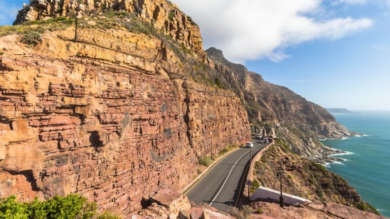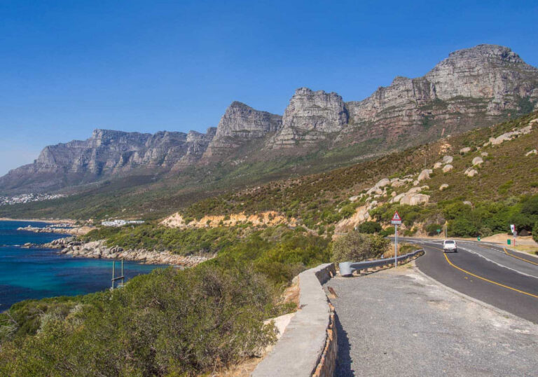
Clarence Drive is the R44 as it runs from Gordon's Bay to Rooi-Els along the eastern edge of False Bay, held between mountain slopes and the sea. The appeal is the drive itself: the town falls away within minutes, the coastline turns increasingly wild through Kogel Bay, and the Cape Peninsula recedes across the water behind you. Around half an hour without stopping, on a free public road.
Clarence Drive is the stretch of the R44 that leaves Gordon's Bay and runs south along the eastern edge of False Bay, held between mountain slopes on one side and open water on the other. It is a public road rather than a built attraction, but it is one of the few roads in the Cape where the journey really is the reason to go. For CapeCurated the drive is the run from Gordon's Bay to Rooi-Els, roughly twenty-five kilometres of coastline that begins in a harbour town and ends somewhere that feels a long way from Cape Town. The R44 continues beyond Rooi-Els toward Pringle Bay, Betty's Bay and Kleinmond, but this shorter stretch is where the drive is at its most concentrated.
Leaving Gordon's Bay, the built edge disappears quickly. The road lifts onto the flank of the Steenbras mountains, the town drops behind you within a couple of minutes, and from then on there is very little between the tar and the sea except rock and fynbos. The road bends around headland after headland, sometimes high above the water with the surface a long way below, sometimes dropping close enough that you can watch the swell working against the boulders. Coves appear and are gone again. Kogel Bay arrives as the first real opening in all that rock, a long pale beach set under the mountains, and it tends to be the point where the drive stops feeling like a road out of town and starts feeling genuinely remote. After that the mountains take over almost entirely, the slopes crowd in above the road, and the approach to Rooi-Els comes as a quiet, low-key arrival at the far side of that transition.
What sets this drive apart from Cape Town's Atlantic coastal roads is the direction you end up looking. On the Atlantic side you look out at open ocean. Here you spend the drive looking back across False Bay, with the Cape Peninsula on the far horizon growing steadily fainter as you go. On a clear day it is a strange and rather good feeling: the city you started from is still visible, but it is over there now, across a great width of water, and every bend puts a little more distance between you and it.
The mountains above the road belong to Steenbras Nature Reserve, the catchment and protected mountain landscape sitting behind this coastline with its dams, trails and controlled access. Clarence Drive is the outside of that landscape, travelling around its seaward edge without entering it. Down on the water, False Bay is well known for whales in the colder months, and during winter and spring they are sometimes visible from the road or from a stopping area. It is worth keeping an eye out, but not worth planning the drive around. Nothing is guaranteed, and the drive earns its place regardless.
Practically, there is no gate, no fee and no opening time. Without stopping the run takes around half an hour, though most people take a good deal longer. It asks more of a driver than the Atlantic Seaboard roads: narrow in places, continuously winding, exposed to wind, and prone to sudden changes in weather and visibility. It is also a favourite with cyclists, so expect to come around a blind bend and find them. Use the proper laybys, parking areas and viewpoints if you want to look properly, and do not stop on the roadway itself for a photograph, since sightlines are short and there is often no shoulder to speak of. Falling rock, fire and storm damage can close the road at short notice, so it is worth confirming it is open before making a special trip to drive it.
Highlights
- The R44 running between mountain slopes and the sea along the eastern edge of False Bay
- Gordon's Bay giving way to open, exposed coastline within minutes
- Kogel Bay's long beach set beneath the mountains
- The Cape Peninsula receding across the water behind you
- Rugged coves, headlands and clear water below the road
- A free public road with no gate, toll or opening hours
Tips
Drive it in clear weather, when the far side of False Bay is actually visible. Allow much longer than the half-hour driving time suggests. Stop only at proper laybys, parking areas and viewpoints, never on the roadway itself. Take the bends slowly and watch for cyclists, who use this road heavily. Check that the road is open before making a special trip, as rockfalls, fire and storms can close it. Travelling from Gordon's Bay toward Rooi-Els gives the landscape its most natural progression.
Frequently Asked Questions
What is Clarence Drive?
Clarence Drive is the name given to the R44 coastal road along the eastern side of False Bay. For CapeCurated the drive runs from Gordon's Bay to Rooi-Els, with the mountains on one side and the bay on the other. The R44 carries on beyond Rooi-Els toward Pringle Bay, Betty's Bay and Kleinmond.
How long does the drive take?
Around half an hour from Gordon's Bay to Rooi-Els without stopping. Most people take considerably longer, and it works well as a half-day outing with a stop or two along the way.
Is Clarence Drive difficult to drive?
It is a normal tarred public road, but it is narrow in places, continuously winding and exposed to weather. Take the bends slowly, watch for cyclists, and stop only at proper laybys and parking areas rather than on the road itself.
Can you see whales from Clarence Drive?
False Bay is a well-known whale area in the colder months, and whales are sometimes visible from the road or from a stopping area during winter and spring. It is worth watching for, but not something to plan the drive around.
How does it compare with Chapman's Peak Drive?
Chapman's Peak is the engineering spectacle, a shorter toll road cut into a cliff face. Clarence Drive is longer, wilder and far less built. Its appeal is the sense of the city falling away behind you as the coastline becomes more remote.